|
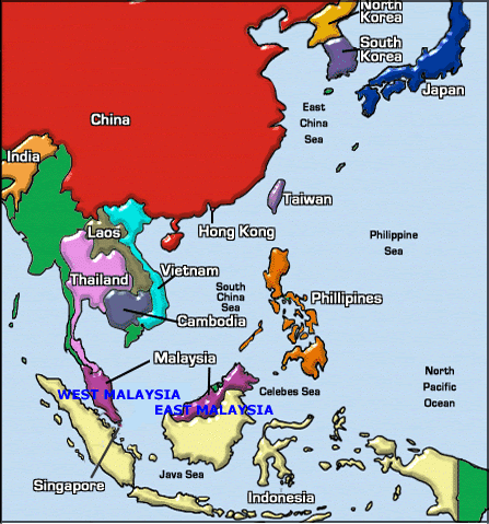
Malaysia consists of West Malaysia (Peninsular Malaysia) and East Malaysia. The two distinct parts of Malaysia, separated from each other by the South China Sea, share a largely similar landscape in West and East Malaysia feature coastal plains rising to often densely forested hills and mountains, the highest of which is Mount Kinabalu at 4,095.2 m on the island of Borneo. The local climate is equatorial and characterised by the annual southwest (April to October) and northeast (October to February) monsoons. |
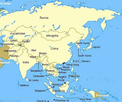 Malaysia is located in South East Asia region in the Asia Continental. North of Malaysia is the neighbouring countries of Thailand, Burma and China. South of Malaysia is the neigbouring countries of Singapore and Indonesia. Philippines is the neighbouring country in the east of Malaysia.
|
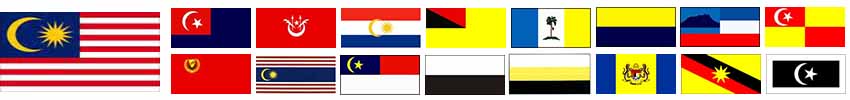
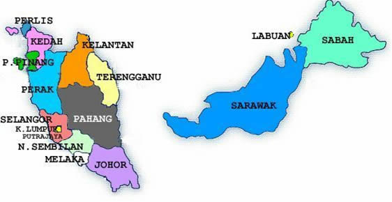
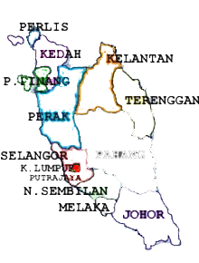
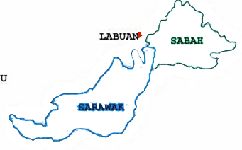
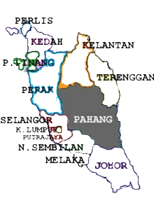
Malaysia has 14 states in total. West Malaysia consists of twelve (12) states i.e. Johor, Kedah, Kelantan, Melaka, Negeri Sembilan, Pahang, Penang, Perak, Perlis, Selangor, Terengganu and Federal Territory (Wilayah Persekutuan in Malay language) which made up of Kuala Lumpur, Labuan and Putrajaya. East Malaysia consists of two states i.e. Sabah and Sarawak. The capital of Malaysia is Kuala Lumpur. Tanjung Piai, located in the southern state of Johor, is the southern most tip of continental Asia if Singapore, an island connected to the continent by a man-made causeway, is excluded. Malaysia is surrounded by Straits of Malacca and South China Sea. The Straits of Malacca, lying between Sumatra and West Malaysia, is arguably the most important shipping lane in the world.
|
 |
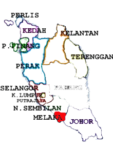
| Map of JOHOR | |
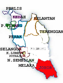 |
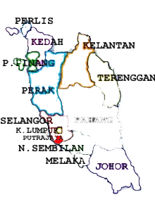
JOHOR is the third largest state in Peninsula Malaysia (West Malaysia) covering 18,987 square kilometres. The State is bounded on the north by Malacca and Pahang, on the west by the Straits of Malacca, on the east by South China Sea and on the south by Singapore. With an economy based on a mix of agriculture, manufacturing, commerce and tourism, it is easily one of the most developed states in the country. It is also a major produces of oil palm, rubber and pineapple. Around Johor Bahru and other major towns, one can find many industrial estates that produce electronic components, electrical appliances, furniture, textiles and petrochemical products. Its population of about 2.83 million comprises of a multi-racial mix of Malay, mostly of Javanese and Bugis decent as well as Chinese, Indians and others. |
| Map of KEDAH | |
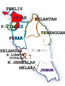 |
KEDAH spans approximately 9, 425 square kilometres in the northern part of Peninsula Malaysia (West Malaysia) and shares a common border with neighbouring Thailand. It has the population of 1.69 million and is traditionally known as the "Rice Bowl of Malaysia". The Kedah-Perlis rice plains produce more than half of the country's home grown rice supply. Alor Setar, the capital state, is the seat of Government and the business centre of the state and also home to many old buildings which still stand in their original form together with other relics of the past. The flat expanse of padi fields against a backdrop of rolling hills provides a picture of utter serenity that lulls the senses. Off its western shore, are clusters of sun-drenched islands that comprise the legendary islands of Langkawi. Relics uncovered at the Bujang Valley, point to Hindu-Buddhist influence dating back to the fourth century A.D. |
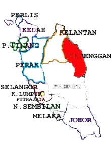
| Map of KELANTAN | |
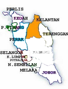 |
KELANTAN, which translate as the 'Land of Lightning' is the northernmost state on the East Coast of Peninsula Malaysia (West Malaysia). It has an area of 15,024 sq km with a population of about 1.33 million which 95% of them is Malay. Kelantan is veritable treasure trove of delights, rustic fishing villages, verdant paddy field and languid, palm-fringed beaches. The people of Kelantan have managed to keep alive age-old customs and traditions, thus earning the state a reputation as the cradle of Malay Culture. Here, colorful kites soar upwards defying gravity and giant drums reverberate. Shadow puppets mesmerize audiences and giant tops provide endless fun. |
| Map of KUALA LUMPUR (WP) | |
 |
Kuala Lumpur, a city that is truly one-of-a-kind. You'll find the world in this city but you'll never find anything quite like it anywhere else in the world. For starters, KL (as we fondly call it) has its very own global icon in the PETRONAS Twin Towers, soaring 452 metres above street level and 88 stories tall. This mega structure towers majestically over KL, presenting a universal view of the icon from any corner of the city. Just beneath the Twin Towers are Malaysia's best shopping spots, featuring haute couture brands to trendy street fashions. For those with a penchant for Broadway-like theatres, meet KL's talented acting community that brings you fine shows and performances from the traditional to the satirical. Partygoers will find KL's vibrant night scenes perfect to satiate their appetite for the most happening places to party. But of course, if you yearn to experience the traditional old world appeal of Malaysia's culture and values, the old streets of KL with its captivating day-to-day activities and aromatic smells will charm you. You'll experience this city, with the echoing music of its entertainment outlets, the beam of vehicle lights searching for the perfect late-night snack and colourful streetlights - a spectacle that proves KL as a definite place to visit for world travellers. Here, we will show you the must-see destinations and must-do activities that will thrill you for sure. With so many places to go, a trip to KL may seem overwhelming. But to help, we've rounded up the best attractions that'll guide you in and around this amazing city. |
| Map of LABUAN (WP) | |
 |
Labuan, the international Island Garden Of Borneo is a popular retreat for corporate Asia to relax and recuperate. This is a place where the old and the new complement each other, where traditional ways and hi-tech methods co-exist, where people of diverse backgrounds live in perfect harmony. Labuan has everything one would expect of a tropical island. Surrounding coral reefs provide a glimpse into the fascinating and delicate marine eco-system. Secluded beaches on nearby islands offer quiet solitude. Shipwrecks promise the thrill of danger for expert divers. Lovers of sea sports can enjoy an increasingly wide range of water sports and recreations. As a duty-free port, Labuan is a haven for branded imports. Local customs and traditions, monuments and memorial parks, reflect the rich history of this island. From world-class resorts and five star hotels to broadband telecommunications, Labuan is well equipped to serve as a venue for corporate meetings, incentives, conventions and exhibitions. Its success as a progressive International Offshore Financial Centre in Asia further boosted the island's appeal among the world's rich and famous. As a duty free island, Labuan enjoys many special privileges and facilities. Besides great bargain shopping, the island offers plenty of business and investment opportunities. It has similar status with other free trade zones in Malaysia. They allow raw materials and components used in manufacturing to be brought in and exported free of duty and taxes. such easing of custom control allows many profitable entreport activities to be conducted freely in Labuan. Shipbuilding, ship repair, oil and gas are among the main industrial activities. Other fast growing sectors include banking and finance, tourism and education. Wilayah Persekutuan (WP), in Malay language, is Federal Territory |
| Map of MELAKA | |
 |
Encompassing an area of 1652 sq km, MELAKA (Malacca in English) was founded by Parameswara in 1400 who named his sultanate after the "Malacca" tree; Malacca has provided the stage on which the Chinese, Portuguese, Dutch and English played their roles in shaping history. He subsequently embraced Islam and established the foundations of an empire which reached its heyday during the reign of Sultan Mansor Shah. Its lucrative spice trade and importance as a sea port made it a prized possession in the Far East, resulting in the Portuguese conquest in 1511. After 130 years of Portuguese rule, the Dutch wrested control of Malacca in 1641 and ruled the state until 1826 when it was taken over by the Britain, that stayed on until the Independence Day in 1957. Malacca's 660,000 populations is a polyglot of races comprising Malay, India, Chinese, descendants of the Portuguese and the Baba Nyonya community. Today, Melaka possesses a charm that is all its own. Hail a trishaw for a ride along little streets that wind through a colorful mishmash of architectural styles. Cruise along Malacca river, then walk along hillocks that have tales to tell, of warfare and treachery, romance and heartbreak. |
| Map of NEGERI SEMBILAN | |
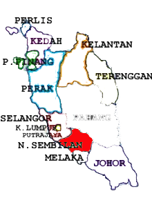 |
NEGERI SEMBILAN, located in the central region of Peninsula Malaysia (West Malaysia), is bordered in the north by Selangor, in the east by Pahang and in the south by Malacca and Johor. It is translated literally as 'nine states' because it once consisted of nine separate districts. The state encompasses an area of 6,645 square kilometres including a 48km gentle coastline. Negeri Sembilan has a population of about 880,000. A first time visitor to Negeri Sembilan would perhaps be drawn to the significant feature of a great majority of traditional houses which have the distinctive style of the Minangkabau people who had migrated across the straits of Malacca from Sumatera centuries ago. Their traditional houses consist of sweeping buffalo horn shaped roof peaks. The Minangkabau of Negeri Sembilan still practice the matrilineal social system known as the "adat perpatih" making the state the only one to adhere to such social norms. Capital of the state: Seremban |
| Map of PAHANG | |
 |
Pahang, with a land area of 35,960 square kilometers is the largest state in Peninsula Malaysia. Nestled in the centre of the Peninsula, Pahang boasts around 210 kilometers of splendid South China Sea coastline on its eastern flank and a mountainous-forested inferior. Ancient Tropical Rain Forests estimated to be around 130 million years old dominate its hinterlands and the best place to discover its magicis none other than the Taman Negara or the National Park. Five of Malaysian's major hill resorts are located in the state, namely Cameron Highlands, Genting Highlands, Fraser's Hill, Bukit Tinggi, and Janda Baik. So is the highest peak in Peninsula Malaysia, Gunung Tahan which stands at 2,187 meters above the sea level. Pahang has a population of 1.5 million people. The majority are Malay, followed by Chinese, and Indians and the Indigenous Peoples. These diverse groups provide a colourful background to the cultural mix and harmony that could easily seen in their daily life. Pahang offers you an adventure of a different indeed. It has a couple of international holiday resorts that sit pretty on the hills enveloped by the world's oldest Tropical Rain Forest. The more adventurous would surely be spoiled for choice with activities ranging from bird watching to white water rafting and four-wheel drive adventure to big game fishing. Even the pictureque fishing villages dotting its coastline would invite the photographer in you to search for those perfect postcard pictures. Capital of the state: Kuantan |
| Map of PENANG | |
 |
Pulau Pinang (Penang), located northwest of Peninsular Malaysia (West Malaysia) about 112 km south of Pulau Langkawi, Penang has been known as the "Pearl of the Orient". The island derived its name from the betel nut trees ("Pinang" in the Malay language) growing in abundance here long before the British set their feet on the island. Captain Francis Light discovered Penang in 1786 and it had since become the first British trading post in the Far East. Numerous historic buildings dating back from the colonial age can still be seen intact on the island today. Capital of the state: Georgetown |
| Map of PERAK | |
 |
PERAK Darul Ridzuan, the Land of Grace, covers an area of 21,000 square kilometres and has a population of about two million. The state is divided into nine districts and its major towns include lpoh, Kuala Kangsar, Taiping, Teluk Intan and Lumut. Kuala Kangsar is the royal town of Perak, while Ipoh is the administrative centre and state capital. For centuries, Perak was renowned for its rich tin deposits. It is believed that the state derived its name, which means silver in Malay, from the silvery tin ore. The discovery of tin by Long Jaafar brought about an influx of immigrants to Perak. Today, Perak has developed into a harmonious multiracial society characterised by a diversity of language, culture and heritage. Capital of the state: Ipoh |
| Map of PERLIS | |
 |
Perlis may be the smallest state in Malaysia, but it boasts a wealth of natural, cultural and historical splendours that rival the bigger states. You may be mesmerised by the many quaint villages, picturesque scenery and centuries-old traditions wherever you go. In short, Perlis is the perfect destination to head for if you prefer old world charm instead of the hustle and bustle of the city, where life is unhurried and the environment naturally fresh and crisp. Perlis lies at the northwestern tip of Peninsula Malaysia (West Malaysia); bounded by Thailand in the north, and by Kedah to the east and south. Its western coastline borders the Straits of Melaka. It measures approximately 810 square kilometres and has a population of 217,480. Capital of the state: Kangar |
| Map of PUTRAJAYA (WP) |
|
 |
PUTRAJAYA is located on a magnificent and wonderful 4,931 hectares of valueble land. It is designed according to the axial tangent which can run from the northest to the southest which take full advantage of its natural surroudings. Therefore, about 38% of the whole Putrajaya is covered with greens and natural plantation and are enhanced with large bodies of water, lakes and wetlands. The main idea to constuct Putrajaya was originated on the 1980's where the New Federal Government Administrative Centre was established. Putrajaya is located at 25km south of Kuala Lumpur and approximately 20km from the Kuala Lumpur International Airport (KLIA). Regarded as the most accesible city in Malaysia, Putrajaya can be reached by using the expressways, urban highways and the railways. Proposed to become a 'Garden City', Putrajaya is focused on preserving the ecological system in its land and expect a comfortable environment full with lush greenery, gardens and parks. Concieved as 'Intelligent City', Putrajaya includes zones that are going to be covered by high-technology companies and Malysia envisions it to become a version of California's Silicon Valley. Capital of Federal Territory: Kuala Lumpur Wilayah Persekutuan (WP), in Malay language, is Federal Territory |
| Map of SABAH | |
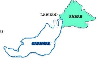 |
Sabah sits at the tip of Borneo, the world's third largest island. Its coastline of 1,440 kilometres (900 miles), washed by the South China Sea on the West and the Sulu Sea and Celebes Sea on the east, that encloses an inland area of 74,500 square kilometres (29,399 square miles). Lying just north of the equator, Sabah enjoys a sunny tropical climate where it's summer all year round. daily temperatures range from 21 - 34 degrees Centigrade, with cooler weather up in the mountains. A land blessed with nature's most bountiful treasures, Sabah is also known by the famed romantic name of "The Land Below The Wind". Picture yourself in a state where the attractions are as varied as they are excitingly fresh and unspoiled beaches, isolated tropical islands, fascinating culture, colourful and beautiful marine life, spectacular countryside dominated by an awesome mountain (Mt Kinabalu, the highest in South East Asia), and where the genuine friendliness and hospitality of the people are part of their tradition. Sabah's State Parks are a naturalist's paradise with their unique flora and fauna. If you are feeling adventurous, go jungle trekking, visit a longhouse and be intrigued by the traditional lifestyle, explore caves, experience rafting, go mountaineering, or dive and discover exciting and colourful marine life. However if you want it - Sabah can be as simple or sophisticated. She has retained her traditional charm and freshness, as well as keeping in step with the 20th century. Sabah will surely impress you with her unique and unspoilt character - truly Borneo's paradise. Capital of the state: Kota Kinabalu |
| Map of SARAWAK | |
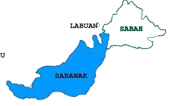 |
SARAWAK or the Land Of The Hornbills, is known as one of Asia's Best Kept Secret as this is a place for history, mystery, romance and exotic adventure no matter on land, hill, or water. Sarawak is the largest state in Malaysia, and is the home of the White Rajahs, the famous hornbills and the highly endangered orang utans. Containing a rainforest that are the size of Austria, it provides the world's richest and most diverse ecosystem available on earth. Besides that, this is also the home to one of the world largest flower, the rafflesia. Living here in Sarawak is a biodiverse type to ethnics such as the Iban, Bidayuh and the Melanau. Famous for its longhouses, spending a night at that place will ensure that you will have an unforgetable moment in Sarawak, sharing the legends that are available here. Sarawak is known to have something for everyone, providing all sorts of entertainment and adventure available. Capital of the state: Kuching |
| Map of SELANGOR | |
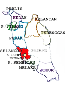 |
Selangor, with an area of approximately 8,000 sq. km, extends along the west coast of Peninsula Malaysia at the northern outlet of the Straits of Malacca. Its advantageous geographic position and rich natural resources have made Selangor the most prosperous state in Malaysia. Today it has the distinction of being the most populated state in Malaysia, with about 3.75 million inhabitants. A large proportion of Selangor's population lives around the Federal Territory of Kuala Lumpur, though the balance is now shifting towards its capital, Shah Alam. Capital of the state: Shah Alam |
| Map of TERENGGANU | |
 |
Terengganu is one of the three east coast states on Peninsula Malaysia. It has a land area of 12,995 square kilometres and 225 kilometres of picturesque coastline. Kuala Terengganu, its capital, stands on the bank of the Terengganu river. Historical records discovered at Kuala Berang showed that an Islamic State existed in Terengganu almost a century before Malacca was founded. Terengganu later became a vassal of Malacca and subsequently Johor. In the 1700s, the present royal family of Terengganu was founded when Mansur Shah became Sultan. The first ruler of Terengganu was Sultan Zainal Abidin, a former Johor Sultan's brother. The state was once a vassal of Siam and had undergone British colonization before gaining independence like the rest of Malaysia in 1957. Capital of the state: Kuala Terengganu |